Data documentation: Aquarius Level 3 Sea Surface Salinity/Wind Speed Standard Mapped Image, Version 5.0 END-OF-MISSION DATA SET
The Aquarius/SAC-D mission, launched on June 10, 2011, is a joint venture between NASA and the Argentinean Space Agency (CONAE). The mission features the sea surface salinity sensor Aquarius and is the first mission with the primary goal of measuring sea surface salinity (SSS) from space. Data from Aquarius will play a large role in understanding both climate change and the global water cycle.
On June 7, 2015 at 12:53:17 UTC the Aquarius/SAC-D observatory suffered a mission-ending hardware failure resulting in the permanent cessation of data flows. The entire Aquarius data record spans a full 3 year, 9 month period from 8/25/2011 – 6/7/2015. Version 4.0 of the Aquarius data is the Official NASA end-of-prime mission data for the Aquarius/SAC-D mission. While no further forward processing of data is possible, a release of a V5.0 end-of-mission dataset is expected in future.
This instrument carries 3 radiometers, and 1 scatterometer. They are operating at 1.4 GHz & 1.2 GHz respectively. The data collected by the radiometer are being used together with sea surface temperature collected from another platform(s), to derive salinity data. This is corrected for surface roughness using data from the Aquarius scatterometer.
The satellite will cross the equator at 6am and pm. The Aquarius instrument will continuously point away from the sun to avoid glint.
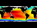
PO.DAAC will be providing Level 2 SSS data as well as gridded Level 3 degree SSS products generated by the Aquarius Ground Segment at Goddard. Level 3 products will be produced with temporal resolutions of daily, 8 day, monthly, 3 months, and annual. Monthly and seasonal climatology products from Aqaurius are also available. The Aquarius instrument will provide global coverage every 7 days. The spatial resolution at Level 2 will be approximately 100km. L3 products are gridded at 1 degree spatial resolution.

