NOAA National Weather Service surface analysis chart showing three strong low pressure systems active and impacting coastal Alaska at the same time. Arrows indicate wind direction; Alaska is outlined in red.
Weather in the northern North Pacific is dominated by a regular flow of storm systems entrained in the prevailing upper-level westerlies and that, in aggregate, define a feature know as the Aleutian Low. The northern North Pacific region is an area that has significant potential for storm development and sustenance, in the form of various thermal gradients and readily available moisture, and so can have several systems active at the same time. The juxtaposition of a major topographical barrier, in the form of the western cordillera of North America, across the path of the westerlies effectively halts the continued eastward propagation of many of these systems.
The main storm track locations, storm frequencies, intensities, and duration are all characterized by strong seasonality.
Winter conditions dominate from November through March. During this time extra-tropical storms regularly develop off of East Asia or in the strong north-south temperature gradients in the North Pacific and progress rapidly northeastward, striking the coast with strong winds, heavy rains, and highs seas. Most of these storms are either Gulf of Alaska Lows, which tend to remain well offshore, or Coastal Lows which approach the coast before developing rapidly.
The Gulf of Alaska Lows tend to linger, and often represent major precipitation events with persistent winds that set the stage for wave generation. They have the potential to cause direct wind damage along the Alaska south and southeast coast and south into British Columbia. The Gulf of Alaska also experiences local-scale wind events, Gap Jets and Planetary Boundary Layer Jets, that can be very damaging.

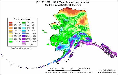
Mean Annual Precipitation for Alaska over the period 1961-1990. http://www.prism.oregonstate.edu/
While not as powerful as the Gulf of Alaska Lows, Coastal Lows can be quite explosive in terms of their development and speed of movement. These systems do not tend to be heavy precipitation events. However, they are capable of causing direct wind damage and most importantly they generate severe sea states that result in coastal flooding due to storm surge and wave action. Occasionally, rainfall is enhanced when the so-called Pineapple Express develops.
These migratory weather systems, along with Upper Level Troughs and Fronts that are associated with widespread precipitation, occur roughly 10-15 times during the months of October to April.
During summer the dominance of the Aleutian Low is supplanted by that of the North Pacific High. As a result the main storm track shifts north, the frequency and severity of the storms is reduced, and weather during the months of May through September is typically mild. Cold Lows, Summer Troughs and Fronts produce most of the weather events during this time of year.

Mean Annual Precipitation for Washington over the period 1961-1990. http://www.prism.oregonstate.edu/
Cold Lows typically occur during the months of May through July. The significance of these features is that they produce large areas of cloud and precipitation, tend to persist in one location for prolonged periods of time, and are difficult to predict.
Locally heavy precipitation events occur in summertime from “air-mass” thunderstorms, which are further enhanced when a trough moves over a region that has already been destabilized by daytime heating.
Sporadic El Niño Southern Oscillation (ENSO) Events profoundly affect weather in the northern North Pacific at an inter-annual scale. They impact the frequency, intensity, duration, and location of storms. Extended periods of elevated sea surface heights that occur in this region of the ocean in association with El Niño Conditions, Coupled with Extreme Tides and High Waves are a particular concern with respect to coastal inundation and erosion. The severe impacts of such events along the Oregon coast during the winters of 1982-83 and 1997–1998 have been well documented.

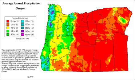
Mean Annual Precipitation for Oregon over the period 1961-1990. http://www.prism.oregonstate.edu/
For a more detailed discussion of the Extremes Climatology of the northern North Pacific go to:
- Gulf of Alaska Lows
- Coastal Lows
- Gap Jets and Planetary Boundary Layer Jets
- Upper Level Troughs and Fronts
- Cold Lows and Summer Troughs and Fronts
- El Niño Conditions, Coupled with Extreme Tides and High Waves
See the glossary for more information about some of the key atmospheric and oceanographic features that affect extreme winds, rainfall, waves and water levels in the Pacific.
See also the WRCC Climate of Alaska
See also the WRCC Climate of Washington
See also the WRCC Climate of Oregon
See also the Weather Patterns of British Columbia


