Marshall Islands Climate Outlook  |
This website provides access to a broad range of information related to seasonal climate variability in the Republic of the Marshall Isalnds. It includes a quick-look at current and future conditions for a range of climate indicators, direct access to more detailed outlook-related information from stations and statellites, and products that place this information in a histrorical context. It also includes links to addtional sources of information.
NOAA State of the Ocean
Surface ocean indices (updated week of 28-APR-2024)
| Pacific | current value |
series std |
current value key » |
monthly tendency key » |
| Niño1+2 far eastern equatorial SSTA map » | 0.20 °C |
±1.10 °C |
 |
 |
| Niño3 eastern equatorial SSTA map » | 0.58 °C |
±0.91 °C |
 |
 |
| Niño3.4 central equatorial SSTA map » | 0.77 °C |
±0.87 °C |
 |
 |
| Niño4 west-central equatorial SSTA map » | 0.81 °C |
±0.67 °C |
 |
 |
Atmospheric teleconnection indices
updated |
latest monthly value |
series std |
latest 3‑mon value key » |
latest 3‑mon tendency key » |
latest 1‑yr mean value key » |
latest 1‑yr tendency key » |
|
| AO Arctic Oscillation | 15-APR-2024 |
0.46 |
±1 |
 |
 |
 |
 |
| NAO North Atlantic Oscillation | 15-APR-2024 |
-0.78 |
±1 |
 |
 |
 |
 |
| PNA Pacific-North America Pattern | 15-APR-2024 |
-0.65 |
±1 |
 |
 |
 |
 |
| PDO Pacific Decadal Oscillation | 15-APR-2024 |
-1.67 |
±1 |
 |
 |
 |
 |
| SAM Southern Annular Mode | 15-APR-2024 |
1.01 |
±1 |
 |
 |
 |
 |
| SOI Southern Oscillation Index | 15-APR-2024 |
-0.30 |
±1.55 |
 |
 |
 |
 |
| AMO Atlantic Multidecadal Oscillation | 15-JAN-2023 |
0.19 |
±0.22 |
 |
 |
 |
 |
value of the index
x = value of the index over the period indicated to the latest value |
tendency
dx = slope of linear fit to values over the period of time indicated, |
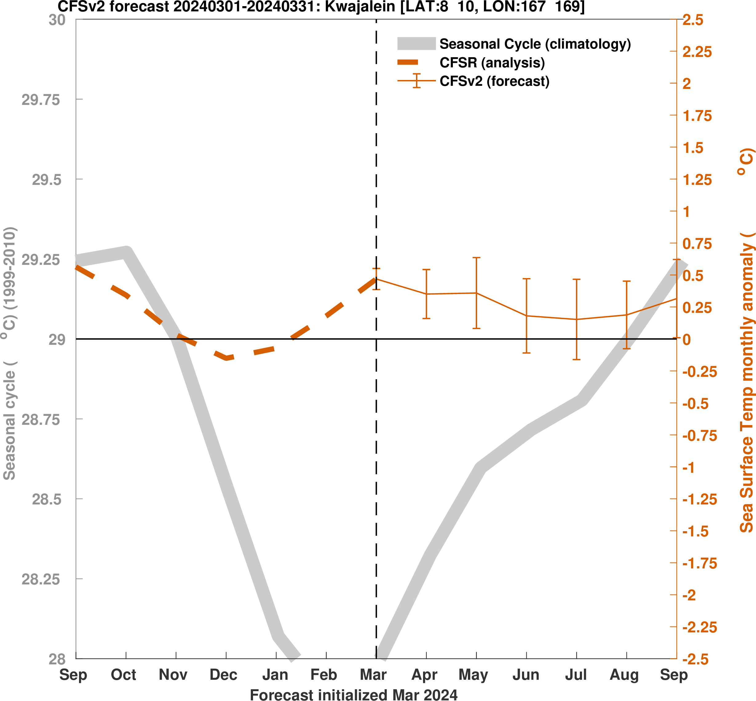
The above plot is based on the National Center for Environmental Prediction (NCEP) coupled forecast system model version 2
(CFSv2).
Forecasts are from initial conditions of the last 30 days, with 4 runs from each day. Forecast ensembles consist of 40 members from
initial a period of 10 days. The figure shows "normal" conditions as approximated by the mean seasonal cycle, past conditions based on
CFSv2 reanalysis, and future projections from the model forecast. The climatology and anomalies are created using values from 1999-2010.
We remove the recent long-term trend (i.e., model drift or bias) from the prediction (e.g., for forecasts issued in 2017 the 1999–2015 trend is removed).
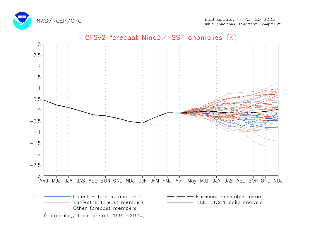
The above plot is based on the National Center for Environmental Prediction (NCEP) coupled forecast system model version 2
(CFSv2).
Forecasts are from initial conditions of the last 30 days, with 4 runs from each day. Forecast ensembles consist of 40 members from
initial a period of 10 days. The figure shows "normal" conditions as approximated by the mean seasonal cycle, past conditions based on
CFSv2 reanalysis, and future projections from the model forecast. The climatology and anomalies are created using values from 1999-2010.
ENSO and other Climate Indices
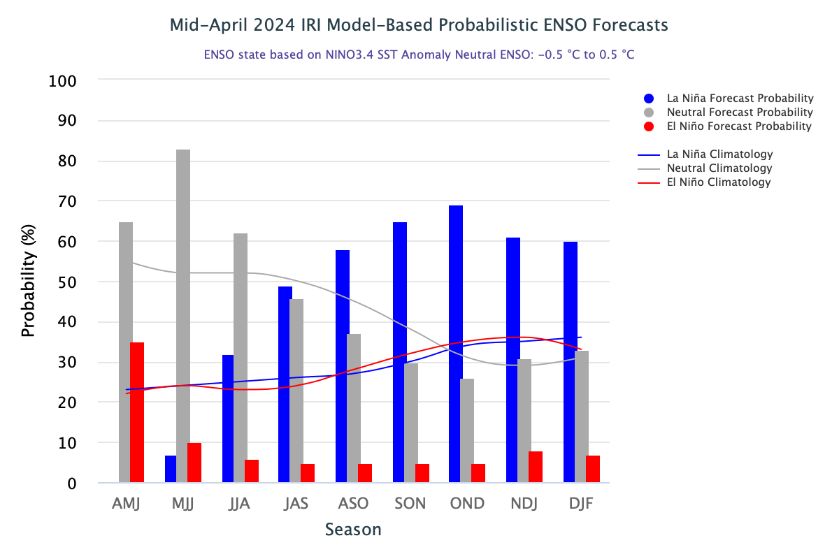
source: http://iri.columbia.edu/our-expertise/climate/forecasts/enso/current/
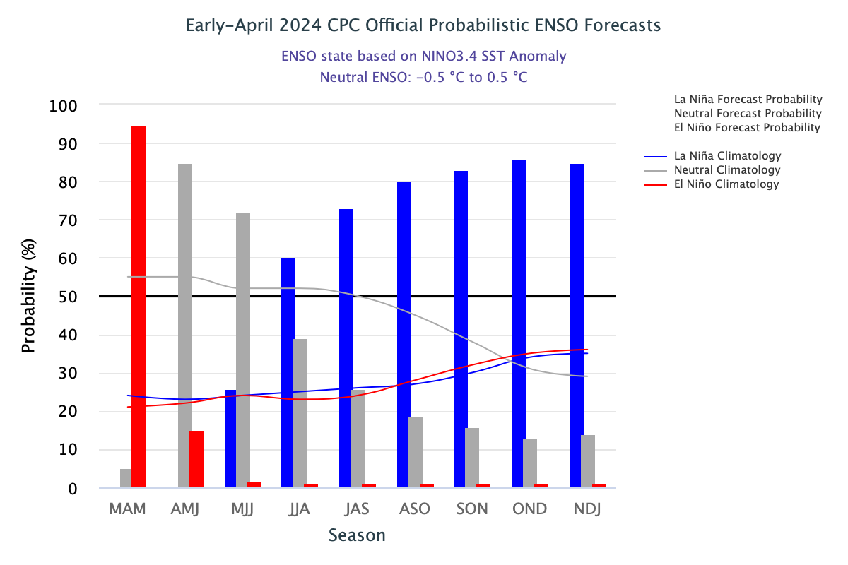
source: http://iri.columbia.edu/our-expertise/climate/forecasts/enso/current/
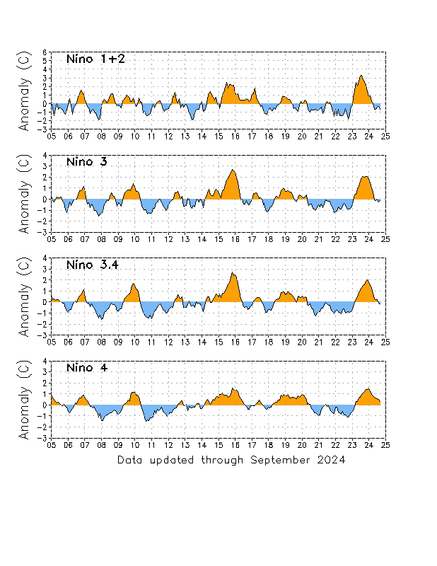
source: http://www.cpc.ncep.noaa.gov/data/indices/


